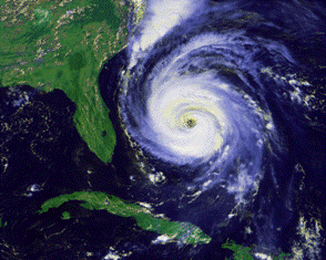
 Living in Florida has many benefits that we all enjoy and living here in North Florida has an extra benefit – during our annual hurricane seasons. Being part of the most western coastline on the Eastern Seaboard, our area has historically proved to be naturally sheltered from most storm activity. We reside in a sort of cove – nestled to the west of the Gulfstream’s steering currents. Those warm currents, tracking south to north, well offshore of us – tend to help steer the paths of passing storms away from us. For over 100 years, direct hits from major storms have been rare in the North Florida / South Georgia coastal zone.
Still, I have always advocated that each of us should know enough about the subject to be educated, stay vigilant and remain calm – each time the weather-entertainers start beating their drums. Over the decades, it seems that any storm-source from the television is overblown and hyped to the limit. Weatherpersons want to entertain more than educate – even though all of their reports are framed in the purpose of generating a sense of readiness.
Take for example the early tracking of Hurricane Irene. In the first 48 hours or so of reporting, the projected landfall moved from the Georgia / Florida state line, to Brunswick, to Savannah, to Charleston and then on to Myrtle Beach. The next morning, when landfall was moved up towards the Outer Banks, the national radio weather reporter closed out his segment with the following: “Residents in Florida are making preparations and getting ready”. Then they threw the microphone to a fellow in Miami (yes, Miami) who was interviewed at his local hardware store as he bought shutters and plywood. Now mind you – as the landfall continued to move north and east, the track continued to move east – so that the folks in Miami could spend their weekend at the beach drinking pina-coladas.
And that is the problem. Disconnected reporting of that kind simply creates confusion and doubt. It enables water-cooler-talk that ranges all over the map: “I heard Irene is going to be a Category 3 hurricane when it strikes Savannah” – “No way, they changed that yesterday afternoon, it is going to cream Charleston” – “You both are out of synch – it was upgraded to a Category 4 and is going to take out Myrtle Beach – all the golf courses are already closed” – “I don’t know what you are hearing but they said this morning that the Home Depots in Miami ran out of plywood and generators.” And so it goes – and interestingly, seldom does anyone really know who “they” are, when referring to the source of their reports.
Know the source and know who “they” are. It is simple and quick and reliable. And once you get in the habit – you will be your own go-to source that will give you comfort and as well as your family, friends, associates and clients.
Since the summer of 2004 (4 criss-crossing hurricanes) I have used, exclusively, 3 weather services / sources for my entire storm tracking (I don’t follow on TV with the local “weather-entertainers”).
www.stormpulse.com – a beautifully interactive tracking map with information imported from the National Hurricane Center in Miami.
www.crownweather.com – an incredible collection of tracking maps and data maps and all of the specific, advisories, discussions and information that is generated from the National Hurricane Center.
www.nhc.noaa.gov – National Hurricane Center website – THE source for detailed and authoritative info that is used by all of the newscasters – NHC gives it to you straight – they leave the drama up to the various weather-personalities. When tropical storm activity starts to build, the NHC posts detailed updates at 5:00AM, 11AM, 5PM and 11PM – with some interspersed times if any storm becomes a real threat.
I recommend that you preview these sites – select one or two or even all three – bookmark them as your favorite – and consult them throughout the advisory and warning stages of any approaching storm. You can get quick updates, on the fly, in no more than a couple of minutes.
In any event, be vigilant (smart and aware) and monitor activities yourself – so you and yours can always Be Prepared.
PS – I can tell you from personal experience – try your best to intervene with any elderly loved one who may be alone at home, glued to the TV, during anytime that the weather-entertainers are practicing their craft. Send them your own updates, gleaned from these suggested sources and try to get your loved-ones to turn off the TV – or at least not get sucked in to the hype and gloom and doom characterizations.


